
Environmental Safety & Natural Disasters in St. Maarten: The Complete Guide
When planning a tropical vacation to the Caribbean, understanding the real-world risks of natural disasters in st. maarten is critical for a safe, stress-free trip. While the shared island is an absolute tropical paradise, its unique geography means it is subject to distinct regional weather and geological patterns.
Many online travel forums provide outdated or overly alarming information regarding local seismic shifts, oceanic currents, and seasonal tropical storms. This ground-tested guide analyzes the actual frequency, modern structural safety standards, and real-time emergency protocols across both the French and Dutch sides of the island.
Read on to learn the exact facts about local earthquakes, tsunamis, seasonal flash flooding, and mountain brushfires.
Table of Contents
- 1 Quick-Reference Island Risk Assessment Matrix
- 2 1. Earthquakes and Tectonic Tremors
- 3 2. Tsunami Risks and Regional Warning Networks
- 4 3. Flash Flooding and Rainy Season Infrastructure
- 5 4. Brushfires and Wildfires on the Hillsides
- 6 5. Hurricane Season Travel Strategy
- 7 Frequently Asked Questions on Natural Disasters in St. Maarten
- 8 Author
⏱️ Core Takeaways: Island Risk Summary
- Hurricanes & Flooding: This is the primary weather risk on the island. The official Atlantic hurricane season runs from June 1st to November 30th, with peak activity hitting between mid-August and late September.
- Earthquakes & Tsunamis: St. Maarten sits near a tectonic plate boundary, meaning micro-tremors happen frequently. However, major destructive earthquakes or tsunamis are exceptionally rare historical anomalies.
- Wildfires & Bushfires: Wildfires are highly localized to dry brush on steep hillsides during the peak winter dry season. They pose virtually zero risk to the main resort districts or tourist beaches.
Quick-Reference Island Risk Assessment Matrix
| Environmental Hazard | Risk Level | Primary Season | Historical Impact on Tourists |
|---|---|---|---|
| Tropical Storms & Hurricanes | High | August – October | Significant structural and flight disruptions |
| Flash Flooding | Moderate | Rainy Season (Sept – Nov) | Temporary road closures in low-lying valleys |
| Earthquakes & Tremors | Low | Year-Round | Minor, imperceptible seismic vibrations |
| Tsunamis | Low | None | Extremely rare; monitored by regional systems |
| Bushfires & Wildfires | Low | Dry Season (Feb – April) | Smoke visibility on secondary mountain roads |
1. Earthquakes and Tectonic Tremors
A common question among nervous travelers is whether St. Maarten experiences earthquakes. Geographically, the island sits on the Caribbean Tectonic Plate near the boundary where it meets the North American Plate. Because of this active subduction zone, seismic activity is a constant, natural part of the region’s geography.
The Reality of Micro-Tremors
The island experiences dozens of micro-earthquakes every single year. However, the vast majority of these tremors register below a 3.5 magnitude on the Richter scale. They occur miles deep beneath the ocean floor.
Unless you are analyzing raw station metadata from the official KNMI Caribbean Netherlands Seismic Network, you will never even feel them. They do not disrupt daily excursions, resort operations, or airport flights. [1]
🌐 Official Tectonic Tracking Channels
- Real-Time Island Waveforms: To view the live seismic data streams originating directly from the island’s tracking instruments, explore the KNMI Caribbean Netherlands Seismic Network portal.
- Tsunami Alert Integration: All active broadband sensors on St. Maarten instantly transmit telemetry directly to the regional Tsunami Warning Center to ensure immediate tourist broadcast alerts.
Structural Engineering on the Island
Following historic regional storms and seismic shifts, building codes across both the Dutch and French sides are strict.
- The Dutch Side (Sint Maarten): Heavy concrete and steel rebar reinforcement are standard for modern resorts in Simpson Bay and Maho.
- The French Side (Saint Martin): Structures must comply with rigorous European Eurocode 8 seismic construction standards.
If a noticeable tremor does occur during your stay, the standard safety protocol is identical to North American rules: drop, cover, and hold on under a sturdy piece of furniture until the shaking stops.
2. Tsunami Risks and Regional Warning Networks
Because St. Maarten is a low-lying island surrounded by the Atlantic Ocean and the Caribbean Sea, travelers occasionally worry about tsunami risks. Statistically, the risk of a destructive tsunami hitting St. Maarten during your vacation window is lower than almost any other natural hazard.
Historical Context and Real Risks
The Caribbean has not experienced a major, catastrophic island-wide tsunami event in modern history. Minor local surges have occurred historically following remote volcanic collapses in the southern Antilles, but nothing capable of breaching the main tourism walls of St. Maarten.
The Regional Early Warning Network
St. Maarten is fully integrated into the UNESCO Intergovernmental Oceanographic Commission Tsunami Warning System for the Caribbean.
- The Infrastructure: Deep-sea pressure sensors and coastal tide gauges track oceanic anomalies in real-time.
- The Protocol: If a major underwater earthquake triggers a tsunami alert, the government issues immediate sirens and mobile network broadcasts.
- How to Respond: Because the island features high volcanic hills immediately behind almost every beach, reaching safety is incredibly straightforward. If an alert is issued, or if you notice the ocean rapidly water receding from the shoreline, immediately walk inland and head up into the elevated hillsides.
3. Flash Flooding and Rainy Season Infrastructure
While earthquakes and tsunamis are rare, flash flooding is a realistic environmental hazard that travelers must actively plan around, particularly during the late summer months.
The Topography Bottleneck
St. Maarten’s unique layout consists of steep, rocky hillsides draining directly into low-lying salt ponds, lagoons, and flat valleys. When a heavy tropical wave or low-pressure system parks over the island, the volume of rainfall can quickly overwhelm local drainage systems.
Flood-Prone Hotspots to Avoid Driving Through
If you are renting a car during a heavy downpour, be aware that three distinct zones collect water rapidly:
- The Philipsburg Pond Fringes: The roads bordering the Great Salt Pond can accumulate up to a foot of standing water during prolonged storms.
- The Lowlands Border Roads: Sections of the road near the Simpson Bay Lagoon can pool water quickly, creating deep puddles that can stall out small economy rental cars.
- The Sandy Ground Pass (French Side): This narrow strip connecting Marigot to the Lowlands sits directly at sea level and experiences localized street flooding during severe afternoon downpours.
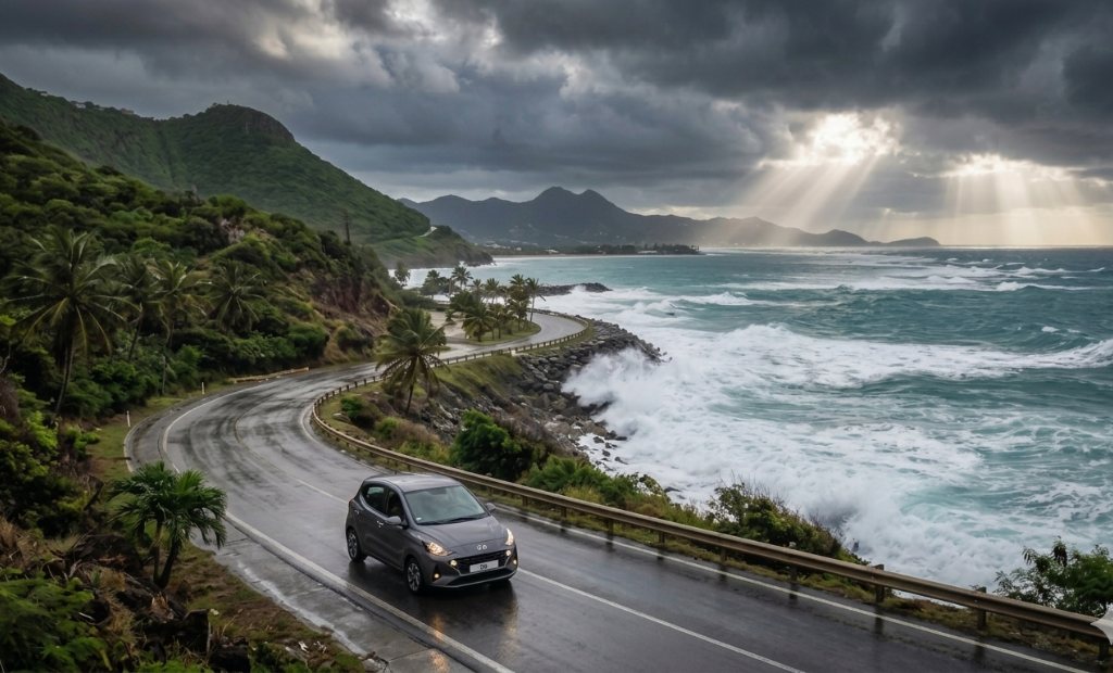
If you encounter a flooded roadway, do not attempt to drive through it. Island asphalt can wash away beneath standing water, creating deep potholes that can destroy your vehicle’s suspension. Turn around and wait for the sun to emerge—island drainage moves quickly once the rain stops.
4. Brushfires and Wildfires on the Hillsides
Wildfires are an environmental factor that rarely receives coverage on mainstream travel sites, yet they occur annually during the peak winter travel season.
The Dry Season Cycle
From February to April, St. Maarten experiences its dry season. Trade winds increase, and rainfall drops significantly. The lush green grass coating the steep slopes of Pic Paradis, Cole Bay Hill, and the French Quarter dries out, turning into highly flammable tinder.
The Tourist Safety Impact
99% of island brushfires are caused by accidental human activity or burning garbage catching the wind on dry hillsides.
- The Risk: These fires are localized entirely to the high, uninhabited mountain ridges. They do not spread down into beachside resort districts like Orient Bay, Dawn Beach, or Maho.
- The Logistics: The main impact on your vacation is temporary smoke visibility on winding mountain highways or minor delays along the secondary roads connecting the French and Dutch sides. Both the gendarmerie and the Dutch fire departments are well-equipped with specialized rugged terrain vehicles to contain these hill fires quickly.
5. Hurricane Season Travel Strategy
You cannot discuss natural disasters in the Caribbean without addressing Atlantic hurricane season. It officially runs from June 1st through November 30th.
The Smart Traveler Window
If you want to completely avoid the risk of severe tropical activity, book your trip during the dry winter and spring months (December through May). If you choose to travel during the cheaper summer and fall months to score deep discounts on resorts and flights, use the following protection blueprint: [1]
- Purchase Comprehensive Travel Insurance: Ensure your policy features a clear “Cancel for Any Reason” (CFAR) clause. Standard insurance will not pay out unless an official hurricane warning is actively issued for the island.
- Monitor the National Hurricane Center (NHC): Modern meteorology tracks tropical depressions up to a week before they approach the Leeward Islands. You will have plenty of advance notice to adjust your airline flights if a storm system tracks toward the island.
- Choose Resorts with Independent Infrastructure: Book larger, established properties (like Sonesta or Simpson Bay Resort) that feature massive industrial back-up generators and independent reverse-osmosis water filtration systems. If you need a fast beach alternative away from the heavy weather swells, check out our guide on getting to maho beach from cruise port docks.
Frequently Asked Questions on Natural Disasters in St. Maarten
Does Sint Maarten have any active volcanoes?
No. While St. Maarten is a volcanic island by geological origin, its hills and peaks are completely extinct. There are no active volcanic vents, fumaroles, or hot springs on either the Dutch or French sides. The nearest active underwater volcano is Kick ’em Jenny, located hundreds of miles south near Grenada.
Are the beaches safe from dangerous rip currents during storms?
No. When a tropical storm or hurricane passes out at sea, it sends massive swells crashing into St. Maarten’s northern and eastern coastlines. Beaches like Guana Bay, Dawn Beach, and Wilderness Beach can develop lethal rip currents during these weather shifts. If you see large, churning waves, stay out of the water and move to protected coves like Anse Marcel or Mullet Bay.
What happens if a storm hits while I am on a cruise ship docking in St. Maarten?
Cruise lines monitor regional weather systems meticulously. If a tropical storm or hurricane tracks toward St. Maarten, the cruise line will completely alter its itinerary days in advance. They will redirect the ship to safe ports in the Western Caribbean or spend the day safely out at sea, ensuring passengers are never exposed to severe weather on the island.